Ocean 101 Cloud 9 Surf report
Siargao Island Philippines
06 November 2013
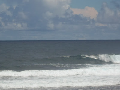


swell 2 days before the super typhoon with the international name "HAIYAN" to hit the philippines , TYPHOON HAIYAN which could become a Super Typhoon before making landfall over Eastern Visayas on Friday, Nov 8. , swell only 1ft ENE knee to waist high uneven, chop-chop and too short wave with lots of water pushing back. the light to moderate winds blowing onshore and forecast onshore the rest of the day, the sun shine with partly cloudy skies and moderate seas, high tide before 8am and low tide at 1.27pm as of 11am zero crowd.
Synopsis:
Northeast Monsoon affecting Northern and Central Luzon. Meanwhile, at 4:00 am today, the eye of Typhoon with International Name "HAIYAN"was located based on all available data at 1,560 km East of Mindano (07.4°N, 140.7°E) with maximum sustained winds of 120 kph and gustiness of up to 150 kph. It is forecast to move west at 30 kph.
Are you planning a holiday or surf trip in siargao? if you are looking for a very affordable, clean and safe accommodation near at cloud 9, http://www.ocean101cloud9.com
for the latest update of cloud 9 surf report please click HOME or like us on facebook and follow us on twitter
Siargao Island Philippines
06 November 2013


swell 2 days before the super typhoon with the international name "HAIYAN" to hit the philippines , TYPHOON HAIYAN which could become a Super Typhoon before making landfall over Eastern Visayas on Friday, Nov 8. , swell only 1ft ENE knee to waist high uneven, chop-chop and too short wave with lots of water pushing back. the light to moderate winds blowing onshore and forecast onshore the rest of the day, the sun shine with partly cloudy skies and moderate seas, high tide before 8am and low tide at 1.27pm as of 11am zero crowd.
Synopsis:
Northeast Monsoon affecting Northern and Central Luzon. Meanwhile, at 4:00 am today, the eye of Typhoon with International Name "HAIYAN"was located based on all available data at 1,560 km East of Mindano (07.4°N, 140.7°E) with maximum sustained winds of 120 kph and gustiness of up to 150 kph. It is forecast to move west at 30 kph.
Are you planning a holiday or surf trip in siargao? if you are looking for a very affordable, clean and safe accommodation near at cloud 9, http://www.ocean101cloud9.com
for the latest update of cloud 9 surf report please click HOME or like us on facebook and follow us on twitter
No comments:
Post a Comment